
Finding potentially suitable orienteering terrains in Croatia and Slovenia
Dražen Tutić, Matjaž Štanfel | University of Zagreb, Faculty of Geodesy, Croatia
Keywords: orienteering terrains, slope, aspect, land cover, multi-criteria analysis
In this paper we describe a method for automated detection of suitable terrains for foot orienteering based on geomorphology and land cover. Existing orienteering maps in Croatia and Slovenia were used as reference data to define criteria for geomorphology and land cover used for GIS analysis. Geomorphology parameters, slope and aspect, were derived from EUDEM digital elevation model. These two parameters define components of direction of surface normal. Land cover criteria were applied using CORINE land cover data set. Analyzed area includes Slovenia, Croatia, Bosnia and Herzegovina and parts of neighboring countries.
While there are numerous methodologies and approaches which could be used for detection of suitable terrains for orienteering running, we decided to use very simple method. Existence of reference areas, from which criteria can be defined and applied to the rest of area, simplifies the procedure and enables evaluation of results. Method is straightforward, thus can be performed using standard GIS with basic raster algorithms.
Selected criteria of slope, aspect and land cover could be related to quality of orienteering terrain in the following manner:
| Criteria | Statistics | Meaning |
| Slope | Value | Too flat terrains usually tend to lack potential details for navigation and mapping therefore not representing interesting terrain for orienteering. On the other hand, too steep terrains can be dangerous due to risk of slip and fall and can be physically too demanding even for elite runners. |
| Slope | Variation | Variation in slope over terrain means that terrain probably has more features that could be used for setting challenging course. Even though slope is in acceptable range that does not mean that there are enough terrain features for challenging courses, e.g. big hill slopes with no valleys, ridges, pits, etc. |
| Aspect | Value | Orientation of terrain towards certain directions is less important (it can be taken for account in some special cases) and generally is not important for selection of orienteering terrains. |
| Aspect | Variation | Variation in aspect over terrain means that terrain probably has more features that are important for setting challenging course. |
| Land cover | Value | Land cover is one of the most important criteria used for this analysis, since foot orienteering is sport organized in forests or natural areas. Sprint orienteering, which is usually organized in urban areas is not subject of interest in this paper. |
First, the data was prepared for analysis. Selected coordinate system was EPSG:3035, Lambert equal area azimuthal projection for Europe. Resolution of raster data was 25 m. EUDEM was downloaded and clipped to area of interest. CORINE data set was projected and converted to raster. Areas of existing orienteering maps and terrains obtained as vector polygons were also projected and rasterized, creating mask of reference areas. From EUDEM, slope and aspect rasters were calculated.
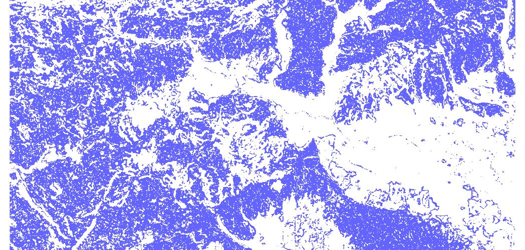
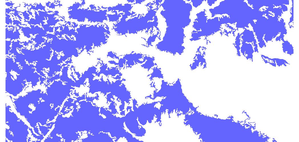
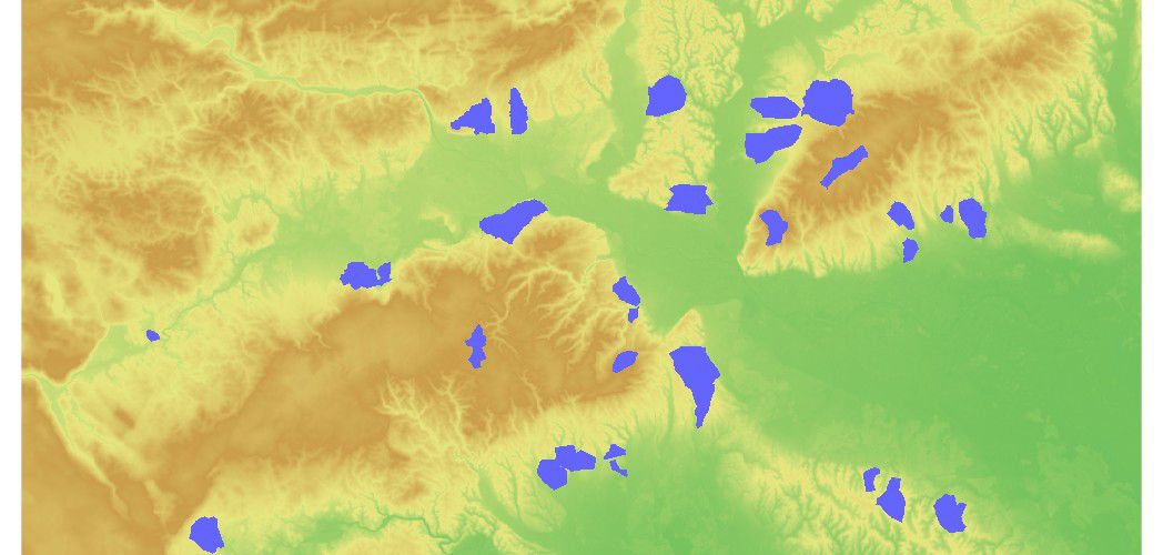 Part of EUDEM data overlaid with areas of existing orienteering terrains (blue)
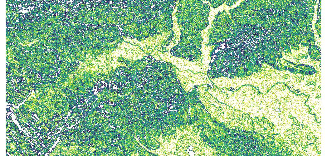
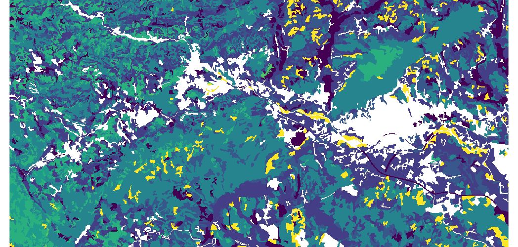
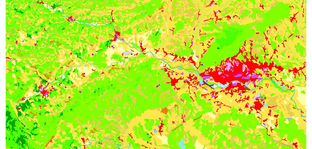 Part of CORINE land cover data set
This type of analysis depends on data resolution. One way to produce more valuable result is to test different resolutions and discover its impact. For this paper we used another approach. Assuming that higher resolutions would yield even better results, we used highest available resolution which is 25 m. Instead of doing pixel-by-pixel based comparison, to obtain better results we have used statistics for certain neighboring area of pixel as input data for analysis. The diameter of circular area is 15 pixels (375 m) and is selected to cover typical length of leg between two control points in foot orienteering which is estimated to be between 200 and 400 m.
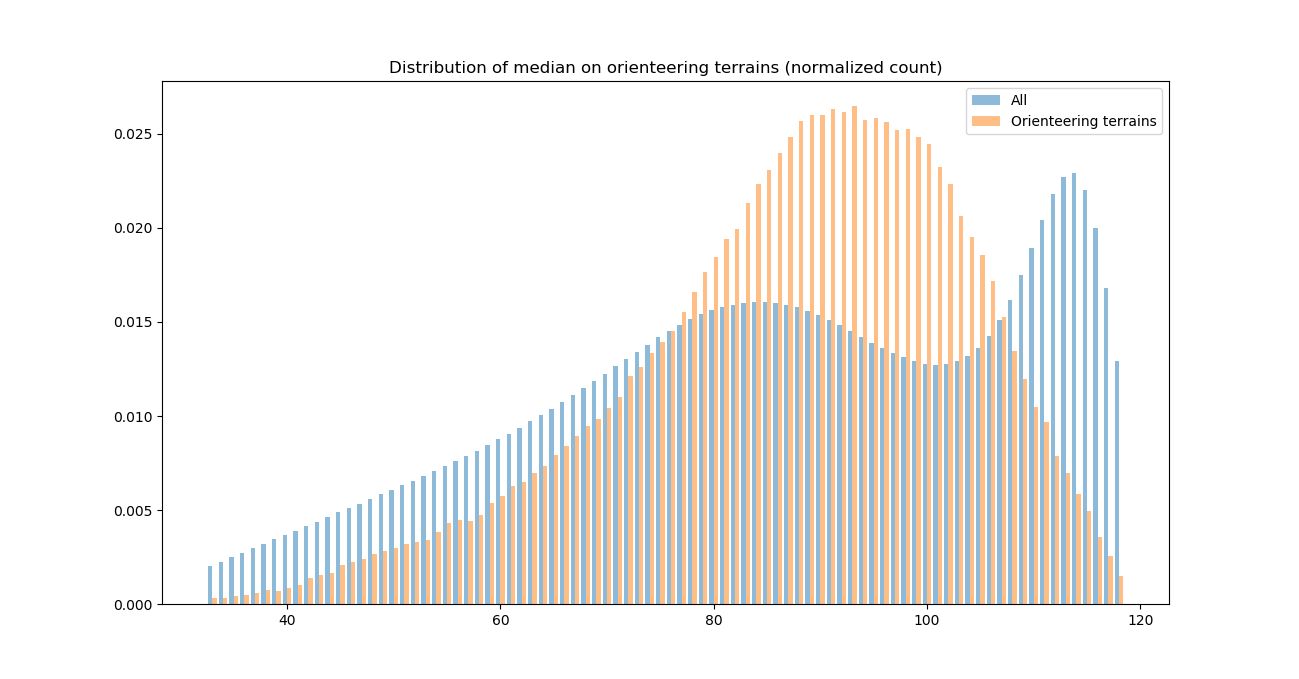
Using neighborhood operator on circular area with diameter of 15 pixels, slope median, 1st and 3rd quartile were calculated. Interquartile range is calculated as 3rd quartile – 1st quartile. Then the histograms for this median and interquartile range were calculated, for the whole area and area under existing orienteering terrains.
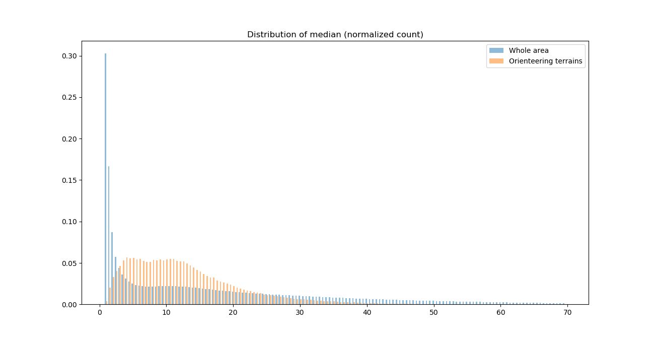 Histograms of distribution for slope median over circular area with diameter of 15 pixels (blue – whole area, orange – orienteering terrains)
 Histograms of distribution for slope interquartile range over circular area with diameter of 15 pixels (blue – whole area, orange – orienteering terrains)
Histograms reveal that orienteering terrains have distinct slope value and variation distribution compared to all terrains. They tend to avoid flat and very steep areas, as well areas with small and very high slope variation. For slope median on orienteering terrains 5th and 95th quantile are 2.8% and 29.2%, and for slope interquantile range they are 2% to 18.5%. These values are used for clipping areas of acceptable slope for orienteering terrains.
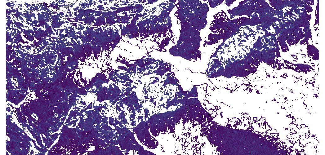 Areas filtered by slope criteria
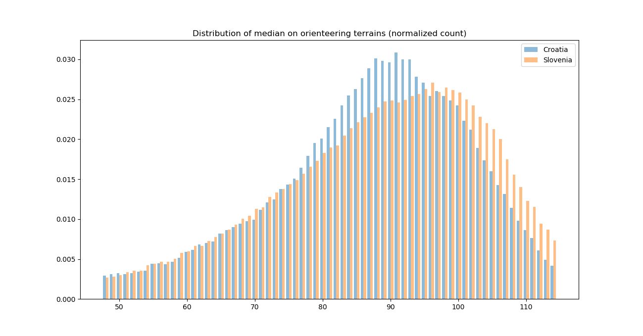
Comparison of slope median and interquartile range distribution for Croatian and Slovenian orienteering terrains shows similar distribution. Histograms of slope median distribution shows that Croatian terrains are a bit steeper then Slovenian, and variation of slope revealed through interquartile range shows almost same distribution.
 Histograms of distribution for slope median inside circular area with diameter of 15 pixels (blue – Croatian orienteering terrains, orange – Slovenian orienteering terrains)
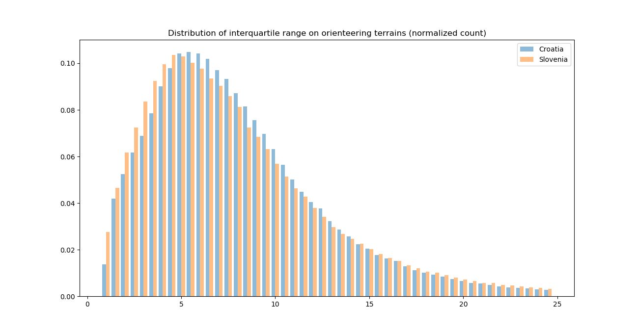 Histograms of distribution for slope interquartile range over circular area with diameter of 15 pixels (blue – Croatian orienteering terrains, orange – Slovenian orienteering terrains)
Aspect was used as second criteria. Since aspect has different meaning than slope, we have used only its diversity indication. This comes from the fact that absolute terrain aspect does not influence quality of terrain, but diversity of aspect is important as challenging courses can be set on terrains with rich terrain features that are reflected through aspect diversity. For that reason, using absolute aspect values which are in range 0-360 is not useful. To obtain value that will reflect diversity of aspect over area of neighborhood operator, first it was rounded to integer, and then diversity (i.e. number of different values) was calculated using neighborhood operator with circular area with
diameter of 15 pixels. Then using same neighborhood operator median of aspect diversity was calculated.
After that being done, the histograms for median of aspect diversity were calculated, for the whole area and area under existing orienteering terrains.
 Histograms of distribution for aspect diversity over circular area with diameter of 15 pixels (blue – whole area, orange – orienteering terrains)
Histograms reveal that orienteering terrains have distinct aspect diversity comparing to all terrains. They tend to avoid areas of small aspect diversity, as well areas with very high aspect diversity. Very high aspect variation (greater than 110) appear in flat areas due to fact that flat areas do not have distinct aspect and digital surface models includes all small objects on ground. For median of aspect diversity on orienteering terrains 5th and 95th quantile are 57 and 110 (number of different integer aspect values). These values are used for clipping areas of acceptable aspect diversity for orienteering terrains.
Question that can be posed here is whether is necessary to limit aspect diversity to upper bound. Flat areas are already filtered by slope parameter, and very high aspect diversity should not be an obstacle for orienteering terrain. This question is to be answered in future work.
 Areas filtered by aspect diversity criteria. Big slopes of even aspect and flat areas are excluded.
 Comparison of median of aspect diversity for Croatian and Slovenian orienteering terrains shows similar distribution and Slovenian terrains tend to offer more aspect diversity, i.e. terrain features.
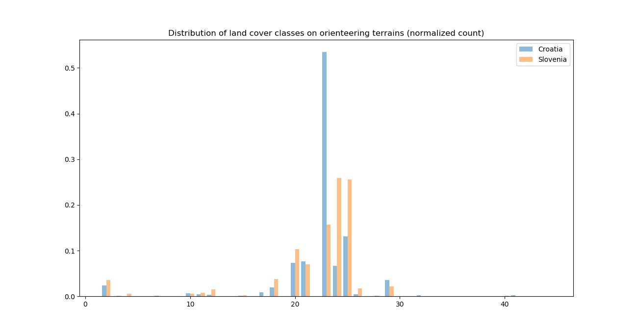
Land cover data in CORINE data set is in nominal scale (distinct land cover classes) and analysis is performed on original data, without using neighborhood operator. Histograms for the whole area and orienteering terrains reveal that forests are the most frequent choice for orienteering terrains (classes 23-Broad-leaved forest, 24-Coniferous forest and 25-Mixed forest). Classes that cover up to 10% of orienteering areas, each, are 20-Complex cultivation patterns and 21-Land principally occupied by agriculture, with significant areas of natural vegetation. Smaller ratio of up to 3% each
is found under classes 2-Discontinuous urban fabric, 18-Pastures, 26-Natural grasslands and 29-Transitional woodland-shrub. From further analysis 2-Discontinuous urban fabric was omitted since this analysis is for foot orienteering and not for sprint orienteering which is usually organized in
urban areas. Existing orienteering maps can have small portion of urban areas that are close to main terrains and that is the probable reason for this appearance (additionally some reference areas are also used as sprint orienteering terrains).
 Histograms of distribution of land cover classes (blue – whole area, orange – orienteering terrains)
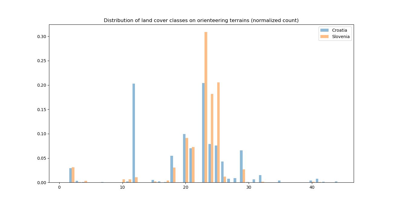
Comparison of land cover for Croatian and Slovenian orienteering terrains shows that broad-leaved forest prevail in Croatia, while in Slovenia most occurring land cover is coniferous and mixed forests.
 Histograms of distribution of land cover classes (blue – Croatian orienteering terrains, orange – Slovenian orienteering terrains)
Filtering of suitable land cover areas was done with classes 18, 20, 21, 23, 24, 25, 26 and 29.
 Areas filtered by land cover criteria
Areas that are potentially suitable for orienteering are given as overlay of three maps (filtered by slope, aspect and land cover criteria) using logical AND operator. Result contains small holes and speckles which affect presentation quality of result.
 Terrains selected as potentially suitable for orienteering
To improve presentation quality of the result, hole filling was performed for holes of area less than 40000 m2 (200×200 m). Such small patches that appears as not suitable for orienteering can be avoided with careful course planning, if necessary. Finally, selected areas that were less than 0.25
km2 were deleted since very small areas are not allowing for proper course lengths.
 Final areas of potentially suitable terrains for foot orienteering
Final step in analysis includes addition of quality information to selected areas. This was achieved by setting arbitrary rules that can indicate quality as follows:
| Raster value | Suitability | Criteria |
| 5 | Excellent | land cover classes 23, 24 and 25, aspect diversity inside its interquartile range |
| 4 | Very good | land cover classes 23, 24 and 25, aspect diversity outside its interquartile range |
| 3 | Good | land cover classes 18, 20, 21, 26 and 29, aspect diversity inside its interquartile range |
| 2 | Fair | land cover classes 18, 20, 21, 26 and 29, aspect diversity outside its interquartile range |
| 1 | Poor | Areas added by hole filling operation |
 Suitability quality of selected terrains (green = excellent, yellow = good, orange = poor)
Evaluation
Using data on existing orienteering terrains gives us opportunity to do some evaluation of selected potentially suitable areas. This will be done in future work.
Publishing
In order to publish and give access to results, final map will be published under CC-BY-SA license using suitable spatial web service. This will enable further evaluation by orienteering experts and field checks.