Mapping the Mountain: The mapping of Mount Ruapehu
Geoff Aitken | NewTopo NZ Ltd
Key words: Mountain mapping, cartography, history, Ruapehu, New Zealand
Abstract. Ruapehu is arguably the most mapped mountain in New Zealand. In 1887 the first ‘comprehensive’ map covering Mt Ruapehu, and adjacent Ngauruhoe and Tongariro, was published to support a proposal for our first National Park. Subsequent mapping, utilising contemporary cartographic developments (in the widest sense), has continuously redefined our knowledge of the mountain’s geography and geomorphology, and encouraged its use for recreation by city dwellers. As an active volcano some features have changed dramatically – some with devastating consequences. The cartographic presentation of basic mapping, recreational mapping and scientific documentation, is presented as a record and compared, as cartographic visualisation and technologies have developed over 130 years.
Geography
 Mount Ruapehu has been the ski playground for both Aucklanders and Wellingtonians since about 1913. It is four to five hours drive from either city. Both refer to it as ‘The Mountain’ – as in, “We are going to the mountain for the weekend”.
The central North Island plateau has been created by volcanism over 250,000 years and earlier eruptions are evident around the massive Taupō caldera, the Rotorua thermal areas, and further north, the active volcano at White Island.
The ongoing activity of this stratovolcano does not deter the skiers and climbers from taking advantage of the opportunities that the elevation of Ruapehu offers.
Volcanism
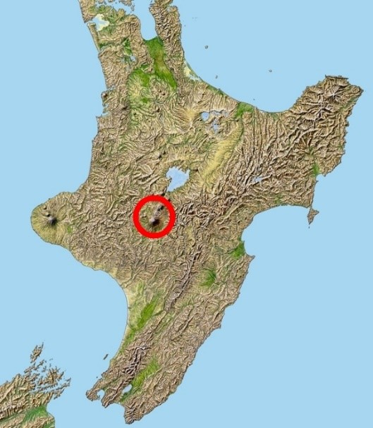
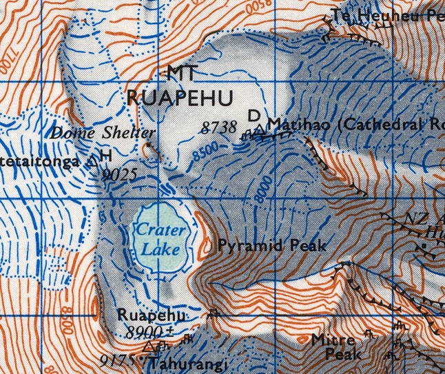
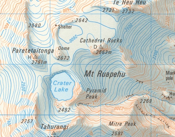
Ruapehu, the largest active volcano in New Zealand, is the highest point on the North Island and has three major peaks: Tahurangi (2,797m), Te Heuheu (2,755m) and Paretetaitonga (2,751m). The 150m deep, active crater lake between the peaks fills with snow melt between major eruptions which occur about every 50 years. The lake temperature normally varies between 15-45C.
The 1945 eruption emptied Crater Lake and dammed the outlet with tephra. The crater slowly refilled with water, until on 24 December 1953 the tephra dam collapsed causing a lahar in the Whangaehu River which destroyed a railway bridge causing the loss of 151 lives.
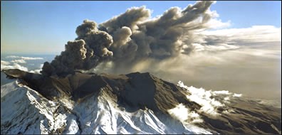
There were significant eruptions in 1995 and 1996. On 18 March 2007, the tephra dam which had been holding back the Crater Lake burst, sending a lahar down the mountain. An estimated 1.4 million cubic metres of mud, rock, and water travelled down the Whangaehu river. Ski lodges were evacuated, and access roads closed.
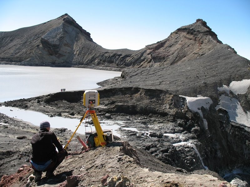
There are fourteen seismic instruments and nine GPS units on the mountain or in the vicinity. The robustness of the natural structures containing the Crater Lake concern scientists, DOC staff and recreation managers, and are continually monitored. Although the basic shape of the mountain is unchanged over recent history, the 14 ‘glaciers’ have shrunk considerably.
The intrinsic dangers on the mountain, in areas sometimes crowded with 10,000 skiers, has necessitated a comprehensive hazard assessment and the development and implementation of comprehensive risk mitigation plans. (Keys 1995. Keys and Green 2007)
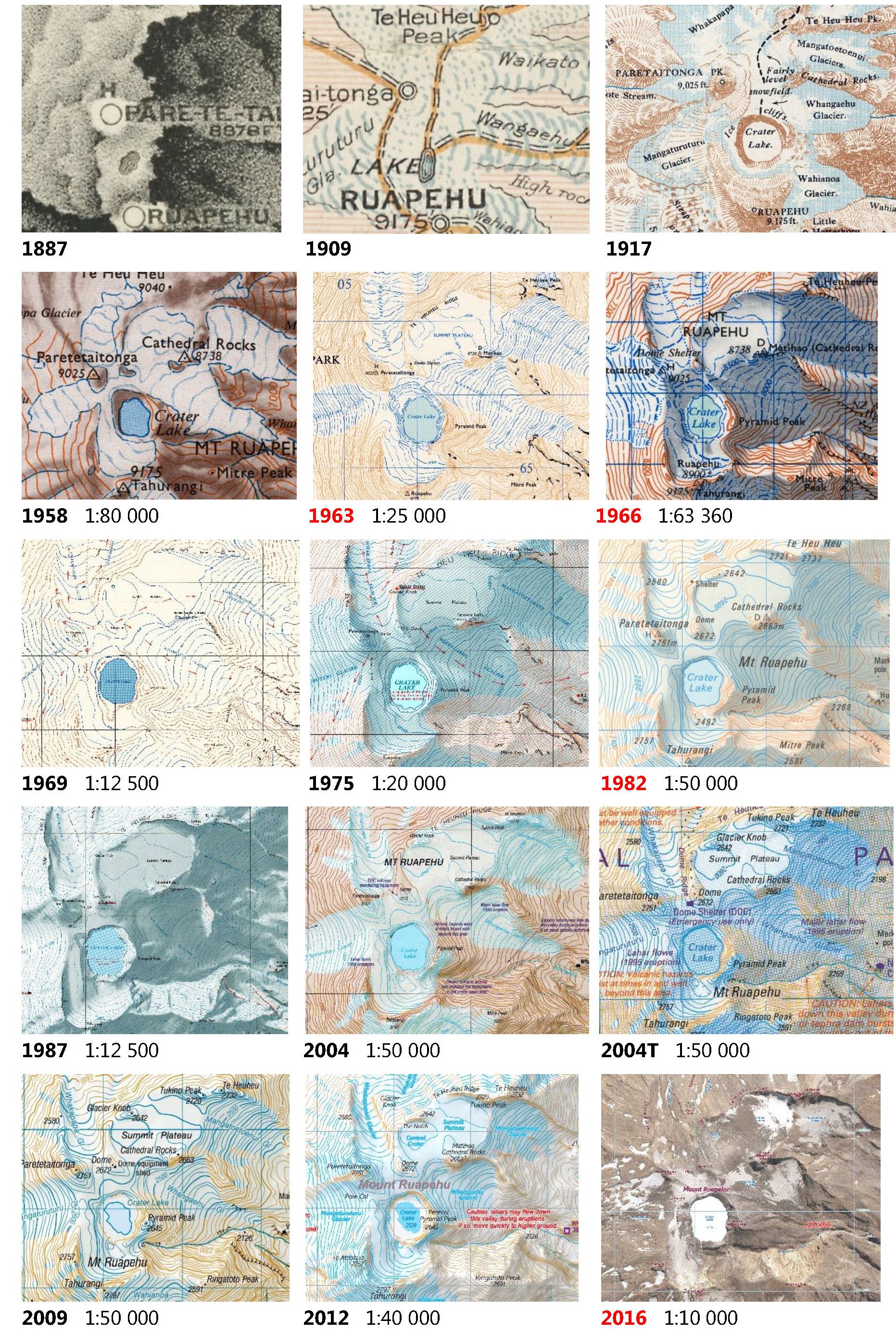
Historical maps 1887 to 1963
 In 1887 a remarkable map was produced to illustrate the proposed Tongariro National Park which resulted from the gifting of the mountains to the people of New Zealand by Paramount Chief Te Heuheu Tukino IV. The map (at 1:126 720 scale) not only shows the context of the proposed park but records the state of geographical knowledge using a rarely seen graphic technique. (Aitken 2014).
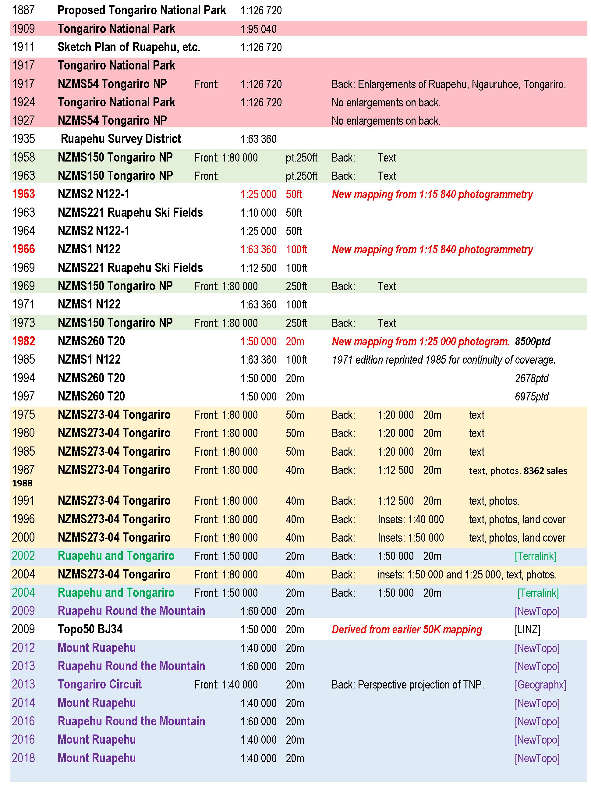
The five maps published in 1909, 1917 (2), 1924, and1927, highlighted in red on Appendix 1, have used the same skeletal base information with minor updates, the biggest of which, in 1927, is the addition of the extended Park boundary which is similar to today’s boundary. This edition has many ‘land cover’ notes, and tracks over mountainous terrain that are shown similarly to the main roads. (!)
A chronological list of published maps is in Appendix 1, and selected map extracts in Appendix 2.
National topographic mapping
The recreational and scientific mapping of Mount Ruapehu has been dependent on the national topographic mapping series.
Before 1963, maps of Mount Ruapehu were dependent on cadastral surveys and sketch mapping. This changed when aerial photography, photogrammetry and cartographic scribing were introduced and became standard contributors to national mapping. First, in 1963, was a map at 1:25 000 scale with fifty foot contours. This mapping was later incorporated into the first mile-to-an-inch (1:63 360 100ft contours) map of the area in 1966. This mapping remained the best available until 1982 when it was superseded by 1:50 000 mapping from new photography and published on the recently adopted New Zealand Map Grid Projection. (Jupp 2011). The 1982 mapping has been the definitive source of contours for Mount Ruapehu until their redefinition 35 years later by Horizons Regional Council in 2017.
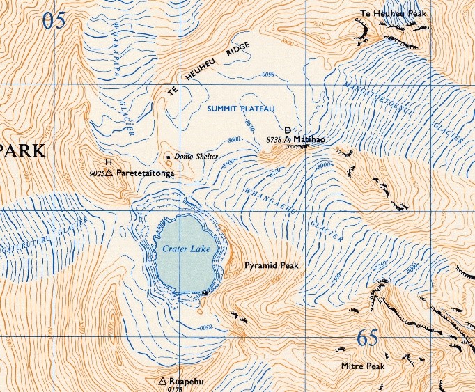 1963 – NZMS2 N122/1: Photography flown on 17 November 1957 at a nominal scale of 1:44 000. Mapped on a Wild A6 stereoplotter at 1:15 840.
Published 1:25 000 with 50ft contours.
Second edition published in 1964.
 1966 – NZMS1 N122: This sheet was mapped from a range of aerial photography covering a period of 14 years, including the photography used to map the NZMS2 above. Topoplots were produced at 1:15 840, which was the standard mapping scale. This was the best available mapping until 1982.
Published 1:63 360 with 100ft contours.
Second edition 1971, reprinted 1985
 1982 – NZMS260 T20: New mapping was produced at 1:25,000 from aerial photography flown on 3 Jan 1975. Essentially, this mapping is still in use.
Published 1:50 000 with 20m contours. Topoplots at 1:25 000 were also available. Further editions were published in 1994 and 1997.
2009 – Topo50 BJ34: Part of the new metric series on the NZTM projection. Same data as NZMS260 sheet T20, but with minor updates (tracks, bridges, huts etc) over the last eight years. No updates were made to contours.
Published 1:50 000 with 20m contours.
Paper and digital editions.
National Park Mapping
Mount Ruapehu is the highest volcano in Tongariro National Park. Since it was first gazetted in 1883 maps have been made available for both the administration of the Park and for recreational users. As better base mapping became available, and Lands and Survey (L&S) became more capable technically and political motivation increased, L&S produced and published increasingly useful maps of National Parks. At that time all national parks were administered by L&S, so the inspiration, compilation and creation of this series was all in-house.
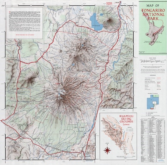 The first real ‘Park Map’ of Ruapehu was NZMS150 Tongariro National Park, published in 1958 with further editions in 1963, 1969, and 1973. This hand drawn map was at a scale of 1:80 000 with descriptive text on the reverse. The first edition featured a hand drawn relief shading in a striking brown colour with 250-foot contours on the eastern side of Ruapehu. These contours were created by plane table supplemented by aerial photographs. An enlargement of the lower Whakapapa ski slopes helped identify the positions of the 30-odd ski lodges.
Publication marked a huge step forward in visualisation and execution.
 The second edition in 1963 used the same drawings but changed the relief to a neutral grey to reduce conflict with other map components. Reference is made on the map to NZMS221 Ruapehu Ski Fields and NZMS186 Walks in the Chateau Area which were separate publications. The 1969 and 1973 editions were very similar in content and presentation. No effort was made to incorporate the larger scale map data that became available in 1966. The editions of this map are highlighted in Appendix 1 in green.
With the availability of mile-to-an-inch mapping, a more comprehensive map was developed to match increased public demand. NZMS273-4 Tongariro National Park was published in 1975 utilising scribing, stripping-film letter-type, and screen tints to produce a more sophisticated appearance. Again, a neutral grey relief was employed, this time supplement by fifty metre contours. The reverse included a 1:20 000 map with 20 metre contours of the top of Ruapehu including all three ski fields. Also included on the reverse were extensive notes on huts and tracks, and an index to names featured on the enlargement.
 Between 1975 and 2004 eight editions were published of this map. In 1988 the fourth edition sold 8362 copies clearly indicating its success as a public document. The 1980 and 1985 editions were almost identical in content and appearance to the 1975 edition, but in 1987 the contour interval was reduced to 40m on the main map and the scale of the ski fields enlargement increased to 1:12 500 with 20m contours. This larger scale effectively replaced the NZMS221 Ruapehu Ski Fields map which was last published in 1969. Duotone photo-graphs were introduced on the reverse as illustrations.
In 1987 L&S was split, with the mapping functions being part of a more commercially oriented Department of Survey and Land Information (DoSLI).
The 2000 and 2004 editions of NZMS273-4 Tongariro National Park were different. The main map introduced twelve land cover categories to aid botanical interpretation and the reverse of the map included smaller insets of the top of Ruapehu and the Tongariro Alpine Crossing, a comprehensive text, and many coloured photographs. Maps of the ski fields were no longer required.
The politically directed reorganisation of government departments in 1996 led to the demise of DoSLI as a centre of cartographic excellence and forced the Department of Conservation to subcontract the production cartography of National Park mapping to private companies. The 2000 edition to of the Tongariro National Park map was produced by Terralink and the 2004 edition by GeoSmart. The editions of this map are highlighted in Appendix 1 in orange.
The Commercial Era
Following its experience with DOC’s Tongariro National Park map in 2000, and using staff that were previously employed on this work within DoSLI, Terralink published its own Ruapehu and Tongariro Recreation Areas map in 2002, followed by a second edition in 2004. This map showed recreational thematic information on a 1:50 000 topographic base. The map was double-sided. Some copies were printed on a synthetic paper.
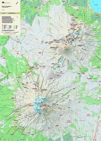
In 2004 NewTopo began publishing mountain maps. An early focus was on the Tongariro National Park with four overlapping maps at scales of 1:30 000, 1:40 000, and 1:60 000. NewTopo’s map of Mount Ruapehu was first published to mark the 8th Mountain Cartography Workshop at Taurewa in 2012. All four maps sell very well indicating a real need and appreciation by the public. The base data for all four maps was derived from the original NZMS260 topographic mapping updated by whatever information is available.
 In 2013 Craig Potton Publishing published a suite of maps of DOC’s ‘Great Walks’ with cartography by Geographx. This included a map of the Tongariro Circuit which also covered the Ruapehu Round the Mountain Track. An overview of the Tongariro National Park on an orthographic oblique projection was printed on the back.
In preparation for the 4th edition of the Mount Ruapehu map NewTopo decided to add a composite image of the top of Ruapehu to the back of the map at 1:10 000 scale. Both summer and winter images were available. The summer image was chosen to encourage people to safely climb to the Crater Lake, or beyond to the peaks…
Visualisation and presentation
Throughout the 130 years the available information has been well presented exploiting the technologies of the time. Innovation in applying the technologies is evident from the blotchy art technique in 1887, the formal hachures of 1917, the bold relief shading of 1958, and the relatively subtle representations since 1982. Most maps have been strictly topographic though recreation-oriented editions added thematic information and text notes to the face of the map. The exception was the short-lived 2000 and 2004 editions of the Tongariro National Park map which included land cover categories.
Afterword:
Physical change
 Although the main structure of the mountain is unchanged, the Crater Lake outlet, which is the beginning of the Whangaehu River, has changed several times. Varying lake levels of up to 10m have caused significant lahar flooding down the Whangaehu Valley in the past. The current outlet is over a lip of ‘solid’ rock and may provide a fixed lake level over the next few years.
Future mapping
The mountain is now quite naked as the snow and ice has melted away. The top is now scientifically monitored to give warning of volcanic evens and subsequent lahars which could threaten life and infrastructure. The published mapping for recreation and administration of the National Park can be expected to be maintained, adding to the continuum recorder here.
Acknowledgements
Dr Harry Keys, DOC. Contributions to feature names. Checking volcanology text.
Chris Kinzett, LINZ (now retired). Assistance with historical photogrammetric facts.
Graeme Jupp, LINZ. Terralink background, history, and loan of the Ruapehu and Tongariro Recreation Areas map.
Andrew Steffert, Horizons Regional Council. Creation of the image mosaic and contours.
Image sources
Maps:
Map extracts are either from the Cartographic and Geospatial Resources Repository, of Auckland University or the Alexander Turnbull Library, National Library of New Zealand.
Photos:
P1 Mount Ruapehu GNS Science. www.gns.org.nz
P5 Crater Lake outlet. Reece Gardner
References and resources.
Ruapehu Geology-volcanic geology and hazards: https://www.gns.cri.nz/Home/Learning/Science-Topics/Volcanoes/New-Zealand-Volcanoes/Volcano-Geology-and-Hazards/Ruapehu-Geology (Accessed December 2017).
Scott, B.J. 2013. A revised catalogue of Ruapehu volcano eruptive activity 1830-2012, GNS Science Report 2013/45. 113p.
Christenson B.W. et al. Cyclic processes and factors leading to phreatic eruption events: Insights from the 25 September 2007 eruption through Ruapehu Crater Lake, New Zealand. Journal of Volcanology and Geothermal Research 191 (2010) 15-32.
Jupp G. ed. NZMS 260 and 262: our metric topographic heritage. CartoPRESS 2011.
Keys H.J.R and Green P.M. 2008. Ruapehu Laha New Zealand 18 March 2007: Lessons for hazard assessment and risk mitigation 1995-2007. Journal of Disaster Research Vol.3 No.4 2008. Pp284-296
Keys H.J.R. Secondary alpine hazards induced by the 1995-1996 eruption of Ruapehu Volcano, New Zealand. Proceedings of the International Snow Science Workshop. 1996. Pp 279-284
Aitken G.D. 2014. The mapping of New Zealand’s National Parks. 9th ICA Mountain Cartography Workshop, Banff, Canada. 22-26 April 2014. http://www.mountaincartography.org/activities/workshops/banff_canada/papers/aitken.pdf
Appendix 1
Mapping timeline for
Mapping the Mountain
Appendix 2
Historical mapping sequence.
Year and scale of publication. New topographic base mapping shown in red.